For most of you, this may not be the first time you’ve heard about Complete Streets. Today, 34 states and over 550 jurisdictions nationwide have Complete Streets policies or resolutions. This is pretty amazing considering that the nascence of the term Complete Streets, and the Complete Streets movement, occurred only ten years ago.
The concept of Complete Streets isn’t new — many elements of the previous scene could describe a recent new-urbanist development or community revitalization project, a Main Street from many US cities in the early 1900’s, or streets around the medieval and ancient world. Even throughout the decades of the very auto-oriented development in America following WWII, we were emulating the positive elements of Complete Streets in the form of indoor and outdoor shopping malls, while unfortunately destroying or ignoring the Complete Streets that already existed in our communities.
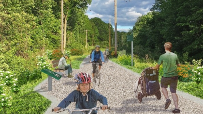
While numerous studies have been done on the health, social, economic and environmental benefits of Complete Streets, much of the instant success of Complete Streets movement is because most people inherently understand these benefits when they experience Complete Streets firsthand. When you think about your favorite streets in America, you think about an environment that is human-scaled: pedestrians have wide rights-of-way; unique landscaping, architecture, and hardscape are intertwined throughout the streetscape; large shade trees provide shelter from the summer heat; you feel safe crossing the street wherever you need to; and it’s just as easy — if not easier — to hop on your bicycle (or bike share bike) or the bus (or lightrail/subway) as it is to drive and find parking.
Sprawling, auto-centric development patterns following WWII caused people to want to drive through Main Streets instead of going to them, and auto-centric city streets caused congestion and crashes. Thus, the emerging field of roadway engineering became mostly focused on vehicular throughput and safety. This led to a favoritism for roadway design that tries to account for human error and negligence by designing for the worst-case scenario in terms of design speed, design vehicle, and traffic flow — known as Passive Design. Passive Design, simply put, strives to remove obstructions that reduce throughput from the roadway, leading to undesirable conditions for community streets — multiple, wide vehicular lanes; wide curb radii with fast turning vehicles; high traffic speeds and volumes; bleak, auto-oriented aesthetics and atmosphere; and confined, uncomfortable sidewalks and bicycle lanes.
While Passive Design is preferred in some contexts — mainly highways and roadways in rural areas — it is detrimental to urban and suburban communities. Passive Design encourages a dependence on auto-transportation, which leads to crippling congestion and other noxious issues.

In contrast to Passive Design, Proactive Design forces drivers to slow down and pay close attention to their surroundings through design elements known as traffic calming strategies. Traffic calming strategies include high-visibility and clearly delineated roadway markings, roadway width reductions, and restricted turning radii — even adding landscaping or other aesthetically pleasing visual elements are considered traffic calming. In turn, Proactive Design promotes walking, bicycling and transit by allowing users of multiple ages and abilities to feel safe and comfortable utilizing these modes to fulfill many of their day-to-day transportation needs.
So if Complete Streets and Proactive Design is superior to Passive Design, why aren’t all of our community streets being designed in this way? One popular answer is that in order to construct roadways with federal funding, which accounts for a substantial number of roadway projects, roadway designs must adhere to standards defined in the Manual on Uniform Traffic Control Devices (MUTCD, which is guided by the National Committee on Uniform Traffic Control Devices, NCUTCD). Likewise, state-jurisdiction roadway projects must adhere to state guidelines, which are in most states largely based on the American Association of City Transportation Officials (AASHTO) manual (as in Illinois). Organizations like AASHTO and NCUTCD have been meticulously refining design standards for US roadways for decades — most of these guidelines are based on the principles of Passive Design, excluding the human-scaled design and traffic calming elements that incorporate Proactive Design.
Despite our rapidly changing transportation habits and urban development patterns, the pace of change in design manuals like AASHTO and MUTCD is very slow. AASHTO took over 12 years to update their bikeway design guide and the NCUTCD committee only meets once every 6 months to discuss and vote upon design guidance changes. Similarly, state design manuals typically adopt guidance provided in the AASHTO guides, and it can take additional years to update a state design manual following national Manual updates.
To try and address the need and public outcry for more innovative, context sensitive and dynamic public rights-of-way guidance in urban areas, organizations stemming from the growing Complete Streets movement like The Congress for the New Urbanism (CNU) and the National Association of City Transportation Officials (NACTO) have been putting together and continually updating best practice design guidelines for Complete Streets design such as the CNU/ITE Walkable Urban Thoroughfares Guide, and the NACTO Urban Bikeway Design Guide and the recently released Urban Street Design Guide. These guidelines are taken from best practices observed in cities like New York, Chicago, Seattle and, San Francisco that are at the forefront of Complete Streets design.
These types of guidelines and design practices are often met with resistance due to the fact that some of the guidelines fly in the face of intensely vetted and widely accepted AASHTO and MUTCD guidance. However, more and more agencies are coming on board with these urban design strategies — recently the FHWA endorsed many portions of the CNU/ITE Walkable Urban Thoroughfares Guide and NACTO Urban Bikeway Design Guide, and Washington State DOT officially endorsed the NACTO Urban Street Design Guide.
While momentum is building in favor of Complete Streets, Complete Streets design principles still often have to be adapted to work within the traditional Passive Design realm. Even in the most progressive US cities, vehicular throughput often takes precedence over pedestrian crossing intervals, on-street parking demand often trumps bikeway installation or upgrades, and highways continue to be expanded while transit networks struggle to even meet their own maintenance needs. However, as cities continue to grow, transportation priorities continue to shift, and more people realize the value that Complete Streets add to our cities and society, the push for Complete Streets will continue to build.
The following image is taken from a project Alta Planning + Design worked on in St. Paul Minnesota. The study team worked with Minnesota DOT to determine the feasibility of Complete Streets solutions for Snelling Avenue — a state-jurisdiction, heavily-used arterial roadway servicing an interstate. The roadway passed through several substantial non-motorized transportation generators such as retail districts, universities, and residential neighborhoods. The final proposal presented a balanced approach to Complete Streets and included concurrent regional transit improvements, all while balancing the traffic demands of the corridor. Recommendations included upgrades such as Bus Rapid Transit, light rail transit, on-street cycletracks (also known as protected bike lanes) in select locations, pedestrian median refuges, pedestrian and bicycle intersection improvements, as well as other Complete Streets elements.