By Heather Seagle, Planner, Alta Planning + Design
We are wrapping up the third year of a Centers for Disease Control and Prevention (CDC) funded Safe Routes to School (SRTS) project in Cabarrus County, North Carolina. Our team has developed SRTS action plans for 11 schools in the county, and in this last year of funding, we are completing four action plans — three elementary schools and one middle school. By working on multiple schools at one time, this project has been an opportunity to examine the commonalities and differences that schools face in terms of walkability and bikeability.
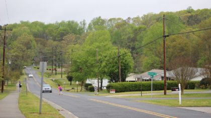
Two of the schools we are working with are located within existing city neighborhoods, one older than the other, but both within established neighborhoods with grid-like street networks surrounding the school properties. The other two schools are in a more rural, unincorporated area of the county, along the same two-lane rural road, with few cross streets and dispersed neighborhood developments.
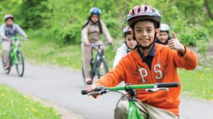
As can be expected, the active travel profiles of the two city schools differ from the two rural schools, with 3–4% walking or biking to the former, and none to the latter. This make sense, since over 30% of students live within a half-mile of the city schools, compared to fewer than 10% for the rural schools. Still, there’s room for improvement. Only 10% of those students who live within a half-mile of the city schools are walking or biking. To close the gap, we have recommended interventions covering the 5 E’s, with infrastructure improvements and programming of various sorts.
Each school’s recommendations are slightly different, tailored to its individual needs and environment. For instance, in one of the rural schools, we’ve recommended a greenway to connect through to one of the neighboring cul-de-sac neighborhoods to provide a connection that bypasses the busy main road. For the other, we’re recommending that the school take advantage of an existing nature trail on adjacent property to incorporate walking-at–school into the curriculum.
In the city schools, bi-lingual parent surveys for Spanish-speaking families have revealed that the fear of crime is just as prevalent of a barrier as safety concerns related to vehicular traffic. In general, parental attitudes toward children walking to school unsupervised tend to skew negative, so designs for on-campus facilities for walking-at-school are being developed, and programs that promote parental involvement, like Walking School Buses and Bike Trains, are suggested.


Equity plays a significant role for all of the schools. The project funding comes from the CDC’s Racial and Ethnic Approaches to Community Health (REACH) Program. As such, schools were selected based on the racial and ethnic profiles of the communities they serve. Incidentally, it is neighborhoods with higher proportions of racial and ethnic minorities that tend to have fewer and poorer pedestrian facilities, and lower rates of physical activity. This project is therefore targeting the communities and environments that need it the most with strategies based on best practices culled from Alta’s experience across the United States, as well as resources from our client and partner, North Carolina’s Active Routes to School project.
These interventions are necessary and impactful, but I can’t help but think that we as planners of healthy communities have to be able to do more, to get involved earlier in the process and make a difference on another level. So much of the opportunity for safe routes to school is already baked in the cake with the school’s location and the surrounding street layout. And too many schools these days are located on the fringes of communities, far from where children live, and without the infrastructure to support walking and biking to school.


So how can we change the landscape of school siting practices and increase the provision of pedestrian and bicycle facilities around schools? And how do we put active transportation access and mobility at the forefront when planning for our schools and communities?
We can begin by expanding the scope of our policy recommendations for SRTS plans to cover school siting policy. This has to be a regular part of the conversation in order to create opportunities to educate and inform communities on the importance of better school siting practices. There are real gains to be made: in opportunities for physical activity, in improved academic performance, for increased access for parent and community involvement, for reduced transportation costs (for schools and individual families), and for reductions in air pollution and other negative environmental impacts.
Policies that support more accessible school locations and that require proper pedestrian and bicycle facility connections can begin to reverse the trend we have seen over the last half-century of schools that are inaccessible by foot or bike. These are not new concepts, and there are existing resources available to help shape our work.(http://www.changelabsolutions.org/publications/smart-school-siting is a good place to start).
Let’s make sure that more schools and communities are aware of these policies and resources, and the need for prioritizing them earlier in the planning process. We can start by making this standard fare for our SRTS projects and any others that can impact school planning.