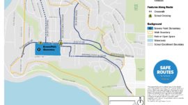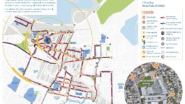
Alta’s Suggested Route Maps combine our team’s SRTS, graphic design, and GIS expertise to develop clear, well-designed maps that facilitate print and digital communication of your community’s SRTS program.
We work closely with communities to develop easy-to-use maps that help families plan their route to school. These maps identify age-appropriate routes to school and other information that is unique to each community’s local context. Our process creates not only maps that are ready to print but also can include GIS data to support interactive map applications.